Travel Information
ISWCS 2010 will be held in the Exhibition Centre at the University of York, York, United Kingdom. Some useful travel information is presented below to help you plan your journey. If you have any queries or would like further information, please don't hesitate to contact us.
Travelling by Air
The following site provides comprehensive information about a wide range of international flights: http://www.skyscanner.net
London Heathrow (210 miles / 336 km from York) is the largest airport in the United Kingdom with regular flights to a large number of destinations worldwide. The airport has several stations on the London Underground, connecting it with central London and Kings Cross station for rail services to York (preferred option). The journey time is approximately 3 hours. Alternatively, trains connect the airport with London Paddington station, from which the London Underground can be taken to Kings Cross station. For more information about flights and travel information see: http://www.heathrowairport.com
London Gatwick (246 miles / 394 km from York) is London's second largest airport with regular flights to a large number of destinations worldwide. The airport has a railway station with a regular non-stop service to London Victoria station. The London Underground connects Victoria station with Kings Cross station for rail services to York (preferred option). The journey time is approx 3 hours 20 minutes. Alternatively, trains connect the airport with London St Pancras International Station, which is adjacent to Kings Cross station (five minute walk). For more information about flights and travel information see: http://www.gatwickairport.com
Manchester Airport (85 miles / 136 km from York) is the busiest passenger airport outside London and provides regular flights to many destinations worldwide. A direct train service connects the airport with York rail station (preferred option), with a journey time of under 2 hours. A similar journey time can be expected by car. For more information about flights and travel information see: http://www.manchesterairport.co.uk
Leeds-Bradford Airport (30 miles / 48 km from York) is a small regional airport with regular flights to many UK and European destinations. It is 45 minutes from the University by Taxi (preferred option), or you can take a bus to Leeds City rail station and then take a train to York rail station, a journey time of around 1 hour and 30 minutes. For more information about flights and travel information see: http://www.leedsbradfordairport.co.uk
Travelling by Train
From Europe - The Channel Tunnel connects the United Kingdom with central Europe. York can be reached in around 5 hours from Paris or Brussels by train, by taking the Eurostar from Paris Nord to London St Pancras, with a short transfer (5 minute walk) to London Kings Cross for a direct rail service to York. It is also possible to travel through the Channel Tunnel with a car, from Calais to Folkestone. For more information see: http://www.eurostar.com and http://www.eurotunnel.co.uk
From the United Kingdom - York is on the East Coast main line from London to Edinburgh, just over two hours away from London (King's Cross) and around two and a half hours from Edinburgh. There is also a direct service across the Pennines between York, Leeds, Manchester and Liverpool. For information about rail services and timetables see: http://www.nationalrail.co.uk
The University is 2 miles (3 km) from the railway station and you will need to walk (about 45 minutes), get a bus (number 4 service from First bus company) or taxi. The University's preferred taxi company is Ebor Taxis, Tel: +44 (0)1904 641441.
Travelling by Car
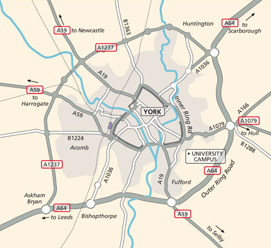
From the North, take the A1 and then either the A59 or A19 to the York outer ring road (A1237). From the South take either the M1 or A1 and then the A64.
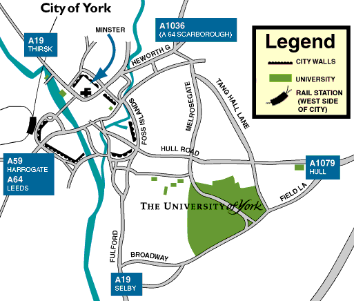
The easiest route to the University is to take the outer ring road (A64 on the south and east sides of the city, A1237 around the north and west) to the junction with the Hull/Bridlington roads (A1079/A166). Turn off at the exit marked University and follow the signs past Grimston Bar park and ride and down Field Lane to University Road. This route avoids the City centre and known traffic blackspots.
Parking - Please note that the University operates a pay-and-display system in the visitor's car parks, and visitors will need a parking permit. If you need a parking permit, please request a permit in advance by e-mailing us.
By Bus To Campus From York Railway Station
The bus is generally a convenient way to reach campus, as the Number 4 bus route runs from York railway station right to the edge of campus. On leaving the station, cross the pedestrian crossing twice, to reach into the central bus terminal island in the middle of the road. From this point an information terminal should give the time until the next Number 4 bus labelled for "University".
The journey on the Number 4 bus takes just over 10 minutes, although perhaps more during periods of heavy traffic. When about to reach the destination stop, the bus will turn sharply right and ascend a hill, and then cross a roundabout. The best departure stop will follow about 30 seconds later, overlooked by a large building on a bank to the left, (the J.B Morrell Library) and an overhead bridge covering it. If travelling on the purple ftr buses, a screen inside the bus will indicate the stops, the stop will be labelled for "Morell Library".
This brings you out upon the edge of Campus. Use the Campus map to navigate towards the Conference location in the Physics/Electronics Exhibition Centre. If you encounter any problems the location of the University Information Centre is nearby, to provide further guidance.
The Number 4 bus can also be boarded from several other locations in town. If you are planning to use the buses to return to accomodation in town, buses in the reverse direction are labelled for "Acomb".
Walking From York Railway Station To Campus
Printable Version of Town Directions Map (PNG) - opens new window
Upon leaving the station, turn right onto Queen Street, and follow the road around the bend to the left. Go over this crossroads, passing Mickelegate Bar (medieval city wall gate) upon your left, and enter Nunnery Lane. Follow this road, past a car park on your left, for about 500 metres, bearing left as you enter Price's Lane. Turn left onto Bishopgate Street, after about 300 metres you will cross the River Ouse. At the end of this road by the roundabout, cross to the other side of Tower Street using the crossings, you should see Clifford's Tower upon an embankment to your left.
Turn right along Tower Street, over the River Foss, and cross Picadilly. Bear left onto Paragon Street. On seeing Toto's Restuarant on your right, cross Paragon Street at the traffic lights. Follow Fawcett Street, and then turn left onto Kent Street. At the crossroads go straight on onto Heslington Road, passing the Victoria pub on your right. Follow Heslington Road for about 800m, and then at the crossroads turn right onto University Road. Follow this up the hill and round the bend to the left, and then over the roundabout. After about 400m you should see Vanbrugh Way on your right, and through it can enter Campus.
Directions Upon Campus To the Conference Location
Printable Version of Campus Directions Map (PNG) - opens new window
ISWCS 2010 will be hosted in the Physics and Electronics Exhibition Centre. To make your way across campus from the bus stop, or after following our walking directions (which bring you opposite the library) please follow the following route:
- Underneath the overhead bridge, cross the road and walk directly across the paved area until you reach a shopping arcade with "Costcutter" and other shops.
- Turn left to reach the covered walkway, and right upon reaching it.
- After about 150m you will emerge in front of a paved area of steps, before a large lake. Turn left opposite the cash machine, and walk past a modern building (the Berrick Saul Building) on your left.
- As you see another covered walkway, turn right and continue past the entrance to Central Hall (concrete building with galleries overlooking the lake).
- Cross the bridge over the lake. Turning right here at the walkway junction bring you into the Physics and Electronics Exhibition Centre.
- Walk through the building concourse area to the other side, the Conference Reception will be located in the glass-fronted section.
Staff at the ISWCS 2010 Conference Reception will be glad to assist you to your accommodation or other locations on campus. If you need further guidance about general matters, the University Information Centre will also be glad to assist you. To reach them, turn right upon facing the shopping arcade, and left by the steps to reach the large glass-fronted building.
Maps

York City road map

Location of University of York campus
NB. These directions do not provide the shortest route, but the easiest to describe to visitors. The distance is just under 3km. Shortcuts can be taken through town streets if you are feeling adventurous, and we would encourage you to explore York during your visit!


